The Valencia region off ers excellent infrastructure for hiking: over 5,000 kilometres of approved paths. The paths on off er include both long-distance paths that allow for interesting treks over the course of several days, as well as small and local trails.
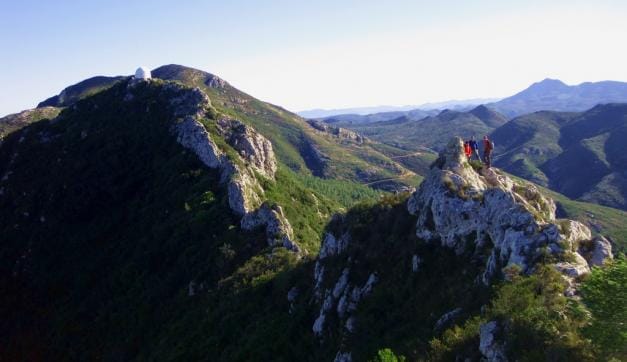
The foothills of the Iberian and Baetic mountain ranges pass throughout the Region of Valencia, leaving a coastal plain that runs from the north to the south of the region until it reaches the northern part of the province of Alicante where the mountains run into the sea. Mountaineering in Valencia has the following among its most emblematic peaks: Aitana, Puig Campana, or Bernia in the mountainous area belonging to the Baetic System. El Penyagolosa, Calderón or El Pina, are some of the mythical names of the summits of the foothills of the Iberian System in Castellón and Valencia. The Valencian Mountaineering Federation and the main climbing centres, such as Valencia, Castellón, Alicante or Alcoi, among others, provide information on mountaineering-related activities in the Region of Valencia.
Main paths for long distance trails in Valencia Region
GR 7 (E-4) This road starts in the Peloponnese and crosses the Valencia Region from north to south, offering a 600-km tour divided into 36 stages between Fredes (Castellón) and Pinoso (Alicante).
GR 10 (E-7) Crosses the Iberian Peninsula from east to west, linking the Mediterranean to the Atlantic. It starts from Puçol (Valencia) and cuts across the Serra Calderona natural park, leaving the Valencia Region through the town of Andilla (Valencia), with a total length of 112 kilometres.
GR 33 Sender de la Lluna Plena (Path of the Full Moon). This trail connects Castellón de la Plana with the peak of one of the most famous mountains in the Valencia Region: the Penyagolosa mountain, located in Vistabella (Castellón). Starting from Les Useres, it matches the path followed every year by the pelegrins de Les Useres. This highly interesting trail stretches across a total length of 56.5 kilometres.
GR 36 Serra d’Espadà. This 60 kilometre path runs through the Serra d’Espadà Natural Park, linking with the GR 7 in the town of Montanejos.
GR 37 Vías pecuarias de la Serranía (Serranía cattle trails). These former cattle trails have been provided with signs to form a circular path that covers part of the Serranía of Valencia.
GR 125 Sendero del poeta (Path of the Poet). This 75-kilometre route was created in homage to Miguel Hernandez, and it covers the southern reaches of the Valencia Region.
GR 160 Camino del Cid (The Path of El Cid). This cultural touristic itinerary follows in the steps of Rodrigo Diaz de Vivar, otherwise known as El Cid, using the Poem of El Cid, one of the great medieval epics of world literature, as its guide. The route begins in a village next to Burgos, from where El Cid left in exile, and ends with the death of El Cid in Valencia, with the option to continue all the way to Orihuela.
GR 231 Ruta de Pinares a Sabinares (From pine groves to juniper thickets). This trail starts at the town of Jérica and ends in the town of Sarrión. It covers just over 63 kilometres between the regions of Alto Palancia (Castellón) and Gúdar Javalambre (Teruel) and it can be covered in 3 stages.
GR 232 Path around the town of Santa Pola. This meeting point for hikers drawing close to Santa Pola is a circular trail starting from the Gran Playa and passing through scenic points such as the fishing harbour, cape Santa Pola, the Clot de Galvany or the salt marshes at braç del Port.
GR 236 Ruta dels Monestirs (Trail of the Monasteries). This touristic route links five Valencian monasteries over 75 kilometres by the sea between Alzira and Gandia.